Tonic Peak

Date: Jan 28, 2017

Participants: Geoff Zenger + a large BCMC party led by Bill Maurer

Difficulty: 2 (mostly easy slopes, short steep section between 21 mile creek trail and valley)

Report: Four years ago I posted a trip on the BCMC trip list for a “mid-winter two-fer”, to go up Mt. Sproatt, traverse over to Tonic Peak, and ski down the hanging valley to the Rainbow Lake trail.  Unfortunately, I was very sick the week before the trip and Bill Maurer volunteered to lead the trip in my stead.  Since then, he has organized a repeat of the same trip each year, trying a slightly different route every time, but never managing to make it to Tonic from Sproatt without running out of time.  This year, I managed to have the date free and decided to join in, and Bill decided that the route would be attempted in reverse: first ascending Tonic, then heading to Sproatt, and skiing back down to Whistler.

A couple logistical mishaps resulted in the party leaving West Van more than 30 minutes late, and so it was about 9am when we finally left the parking lot at the Whistler Cemetery and started our way up the 21-mile creek trail.  The trail towards Rainbow Lake had seen traffic since the previous snowfall, and the going was easy and quick.  Approximately 400m past the outhouses, we found some flagging to the left to the trail and started our way up towards hanging valley.

At this point we were on the left side of a gully, and we learned later from our descent that it would have been easier to ascend to the right side of this gully (but important: still to the left of the main creek flowing out of hanging valley).  Not far up this slope we encountered a cliff band and we were able to work around it to the left, but this necessitated a brief bootpack up a steep snow slope.  On top of this slope, we worked our way to the right, into broad open bottom of hanging valley.  At this point the weather started to warm up towards 0 degrees as the sun came out.  Beautiful!  This is also where we had our only real scare of the day, when we noticed that 2 members of our party had disappeared and we began to worry that they had followed some older tracks up the ridge heading directly to Mt. Sproatt.  A lengthy discussion ensued, and just as we had decided to press on and hope to be able to see them on top of Mt. Sproatt, they caught up to us as it turned out that one of them had had to stop to fasten his bindings more tightly to his skis.

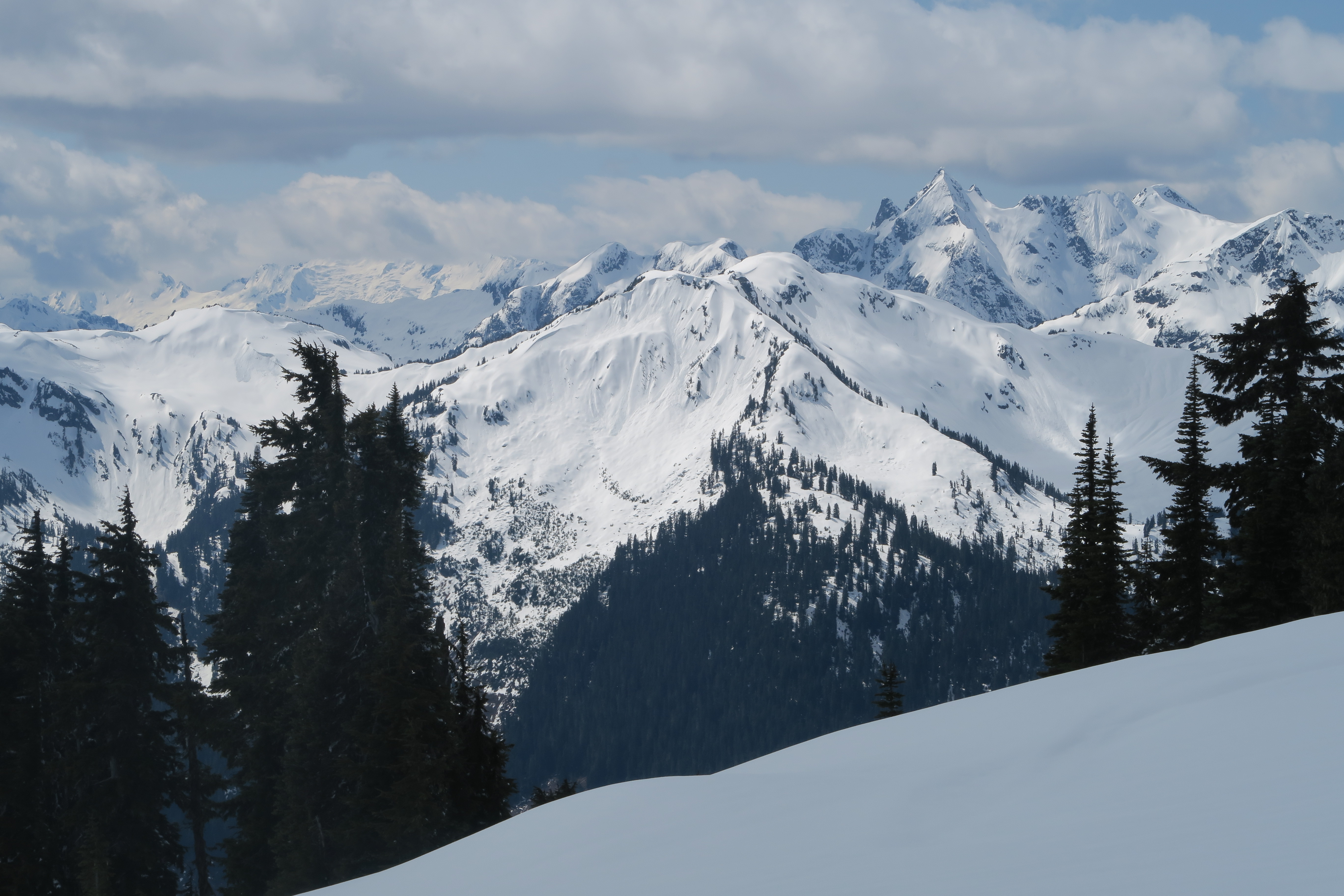
The touring up hanging valley was both easy and very pleasant, and at its head we turned slightly to the left to head up towards the col between Mt. Sproatt and Tonic Peak.  In retrospect, we would have had a more direct route had we ascended through the trees at the head of the valley.  From near the col we turned right and pressed onwards to a little knob in the distance.  Many of us wondered why we were heading there rather than to the taller peak to the right, but our dear leader insisted that it was indeed Tonic Peak.  On reaching “Maurer Knob” however, the GPS was checked and sure enough we were on a minor knob and had to backtrack to begin our ascent to the real Tonic Peak, which we reached at about 1:40, for a total ascent time of 4:40.

The day was clear and beautiful, and from the summit we had great views of the Spearhead Range, Rainbow Mountain, and all of the peaks south of Callaghan Valley.  A quick glance at the time combined with some participants expressing concern about the difficulty of skiing on the descent led to an easy decision to not try to summit Sproatt as well and so we could relax a while on top.  We left the summit after 30 minutes, quickly skinned across the summit plateau, and had a fantastic run straight down into the head of hanging valley on wonderful powder.  Here we decided to stick just to skiier’s right of the main creek, and soon found ourselves at the end of the valley.  Here things got dicey for some of our less experienced skiiers, as descending to the Rainbow Lake trail was essentially a side-slipping clinic.  Nonetheless, everyone made it down to the trail without mishap.  The trail itself resembled a luge track, with many ups and downs, causing headaches for our splitboarder and our newer skiiers, but we persevered, and by 4:30 we were back at the cars.

Many thanks to Bill for organizing, and thank you to everyone else for a great day out in the mountains!  Since having a baby my days out are limited, and it’s wonderful to have days like this with great company and great skiing on those days I do manage to get out.  The route is certainly not a classic, but it is close to home, had great snow, and got us all to a summit that we hadn’t visited before!

Continue ReadingTonic Peak

Metal Dome

Date: May 2, 2015

Participants: Devin Erickson, Brittany Zenger, Geoff Zenger

Difficulty: 1/2

Report: Metal Dome is a popular mountain so I don’t need to say too much.  We started out from the cars at around 9:30, parking right next to the snowmobile cabin up Brandywine FSR.  Hit snow about 5 minutes up the snowmobile access cut from there, and proceeded easily on snow to the summit.  Amazing views, great day.  Total round trip at a very relaxed pace with lots of time on the summit of only about 5 hours.  Great trip for beginners!

Continue ReadingMetal Dome

Mt. Brew (Sea-to-Sky)

Trip Date: Oct 5, 2013

Participants: Wayne Pattern, Christian Molgat, Steve Pollack, Alison Coolican, David Puddicombe, James Lamers, Brittany Zenger, Geoff Zenger

Difficulty: 1/2

Report: Our original plans to head up Cypress Peak scuttered due to a large amount of fresh snow falling in the days before this trip, I looked at a map and changed destination to Mt. Brew, which we ascended via the “winter route” trail and whose trailhead lies only a couple km away from the Cypress Peak trailhead up the Roe Creek main.  The last 1.5 km or so to the trailhead require a 4wd vehicle due to the steepness and looseness of the road, but was otherwise drivable by one of our party member’s Honda Accord.

We departed the trailhead just past 10am under low overcast skies, and after about 30 minutes hit both snow and fog.  Up to Brew Lake the snow was firm enough to be easily traversable without snowshoes, but past the lake those of us who brought snowshoes were very grateful to have them as the rest of the party spent much time postholing in the boulder fields on the route towards the Brew Hut.  On the way up we caught up to a VOC work party led by Roland Burton heading in to replace some windows in the hut, and after this, eventually reached the hut at about 12:40, where we stopped to enjoy a nice lunch in the fog.

We departed the hut for the summit of Mt. Brew at 1:10, and made it to the summit in no time as we were standing on the top at 1:30, once again in total fog and without any views whatsoever.  Bored by the whiteness, we didn’t stay long and soon started on our way down to the cars, which we arrived at before 4pm, making for a very relaxed trip of less than 6 hours.  The terrain in general is very mellow and the trail is pleasant enough, it’s just too bad that we couldn’t see a thing at all for the entire day.

Continue ReadingMt. Brew (Sea-to-Sky)

Gin Peak

Trip Date: January 15, 2012

Participants: Dave Robertson, Andrzej Jarzabek, Jamal Ahmelid, Giovanni Ghigliotti, Caroline Le Bouteiller, Ed Zenger, Geoff Zenger (organizer)

Difficulty: 2

Report: Despite the best efforts of the staff at Whistler Olympic Park (WOP) to frustrate our day, my second BCMC trip of the weekend ended up a great success.  Originally we intended to meet at 8am sharp at the base of the ski jumps, but the WOP officials decided that this was not to be the case.  Despite the gate being fully manned when we arrived at 7:45am, the woman inside informed us that we could not pass until 8:30 sharp, when the park officially opened.  We (along with some other backcountry users not aware of this policy) patiently waited until 8:30, at which point we were directed to go to the main lodge to speak with a patroller, who would inform us on how we could access the backcountry.  On speaking to her, we found out that we would have to pay $10 per person to park in their lot, and furthermore, that they had decided to close all access to the backcountry from the area around the ski jumps (from which the ascent route begins in Baldwin’s description), and that the only permitted access is now from the biathlon area, a km or so to the west.  Nobody we talked to seemed to understand the lay of the backcountry around the park, and I think that it is fair to say that WOP is going out of their way to discourage backcountry users from crossing their territory.

We finally got started from the biathlon facility a bit past 9am, with the intention of heading up to Hanging Lake, and from there, to Gin Peak.  On the far side of the biathlon track, there were two routes apparent to us: one, to the left, went by a box that read something like “backcountry access registration”, and the other, to the right, had no apparent sign other than one saying “ski area boundary”.  If you ever find yourself in this place, do yourself a favour and take the route to the right (the actual Hanging Lake trail), not the one on the left, as we followed the tracks on the route to the left into the middle of nowhere, and then found ourselves contouring around the hill on icy slopes for nearly an hour until we managed to hit the proper Hanging Lake trail.

The Hanging Lake trail was well trodden, easy to follow, and we made quick time up to Hanging Lake.  Of interest, we weren’t far up the trail from where we hit it, and around 1100m, encountered 3 guys hiking up the trail in snow boots, searching for their snowmobiles that they had abandoned above the knoll in the fog the previous night.  It sounded as if they had intended to descend on snowmobile from Hanging Lake to WOP, although it’s hard to see how they thought this would be a good idea, especially given how little snow there is low down.

We had lunch at Hanging Lake shortly after noon, and from there it was a quick jaunt up over the ridge to the south east, where we encountered the snowmobile highway.  Leading up from Rainbow Lake to the west side of Gin Peak was, in effect, a groomed path created by dozens of runs up and down by snowmobiles.  There were at least 12 snowmobiles idling down on Rainbow Lake, and they occasionally darted up and down the slopes of Gin Peak as we ascended them.  We all hit the summit of Gin Peak (my first summit of 2012!) at about 1:45 pm, and took some time to enjoy the views before heading down.

The powder on the first few hundred metres of the descent was fantastic, even for a while below Hanging Lake, and even once the powder ran out, the descent was quick and uneventful.  We were back at the cars by 3:30, and an excellent day was had by all.

Verdict: 2/3.  Not the most exciting peak, but has a very easy ascent, fun descent, good views, and safe in most avi conditions.

Continue ReadingGin Peak