July Mountain

Trip Date: Oct 14, 2013

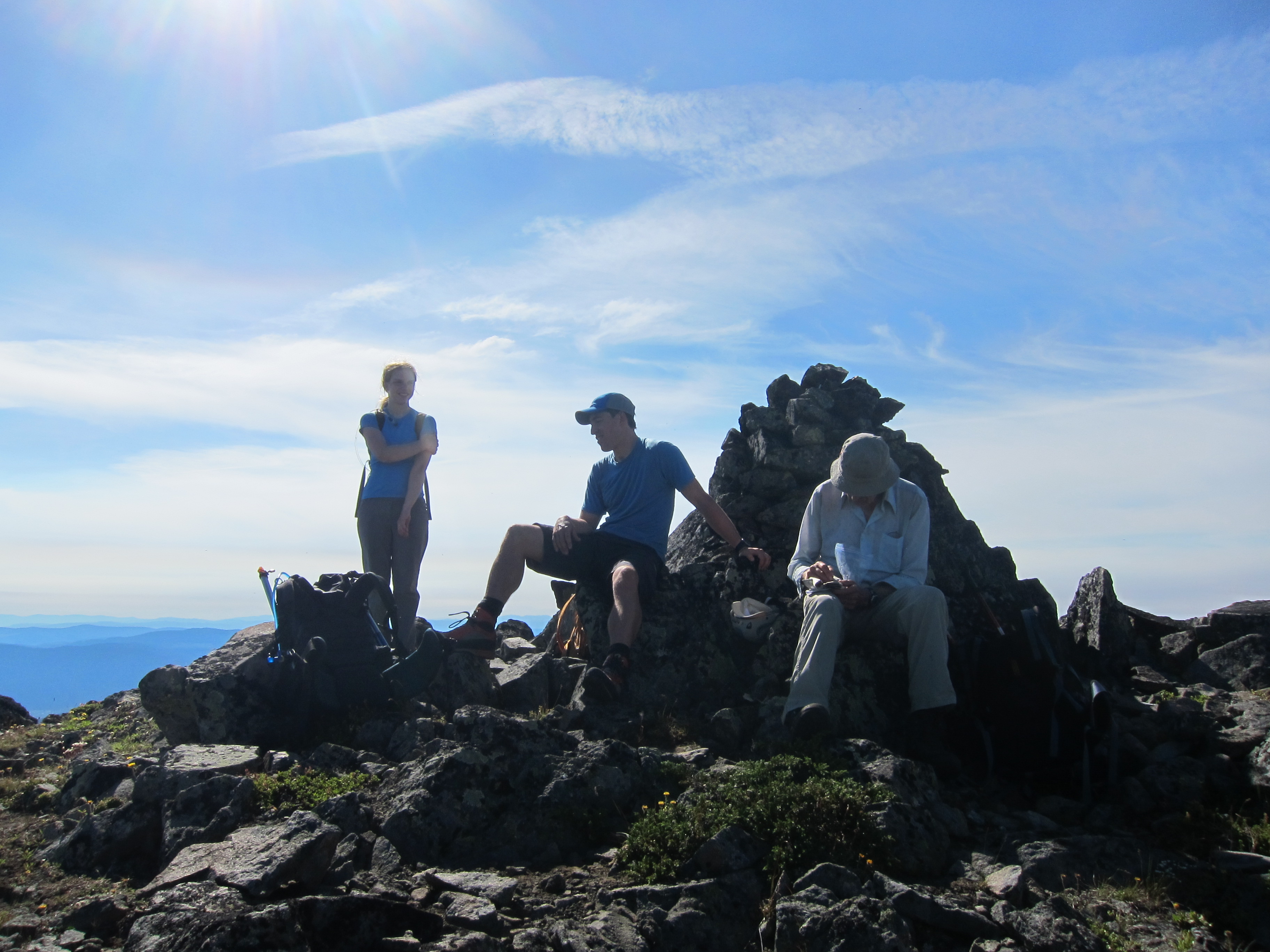
Participants: Brittany Zenger, Ed Zenger, Leslie Zenger, Nancy Zenger, Geoff Zenger

Difficulty: 2

Report: How better to celebrate Thanksgiving than to climb a beautiful mountain with your family?  Thanksgiving Monday 2013 saw my mom, dad, and sister come out with Brittany and I to the Coquihalla to head up July Mountain.  We met up in New Westminster a bit past 7 and headed out towards the Coquihalla, and after breakfast in Hope and a mixup where we missed our turnoff on the highway and had to turn around to go back to the road up Juliet creek, we eventually made our way up the road and left the Jeep where we first hit snow, a 20 minute walk from the normal trailhead, starting up the the road at 10:30.

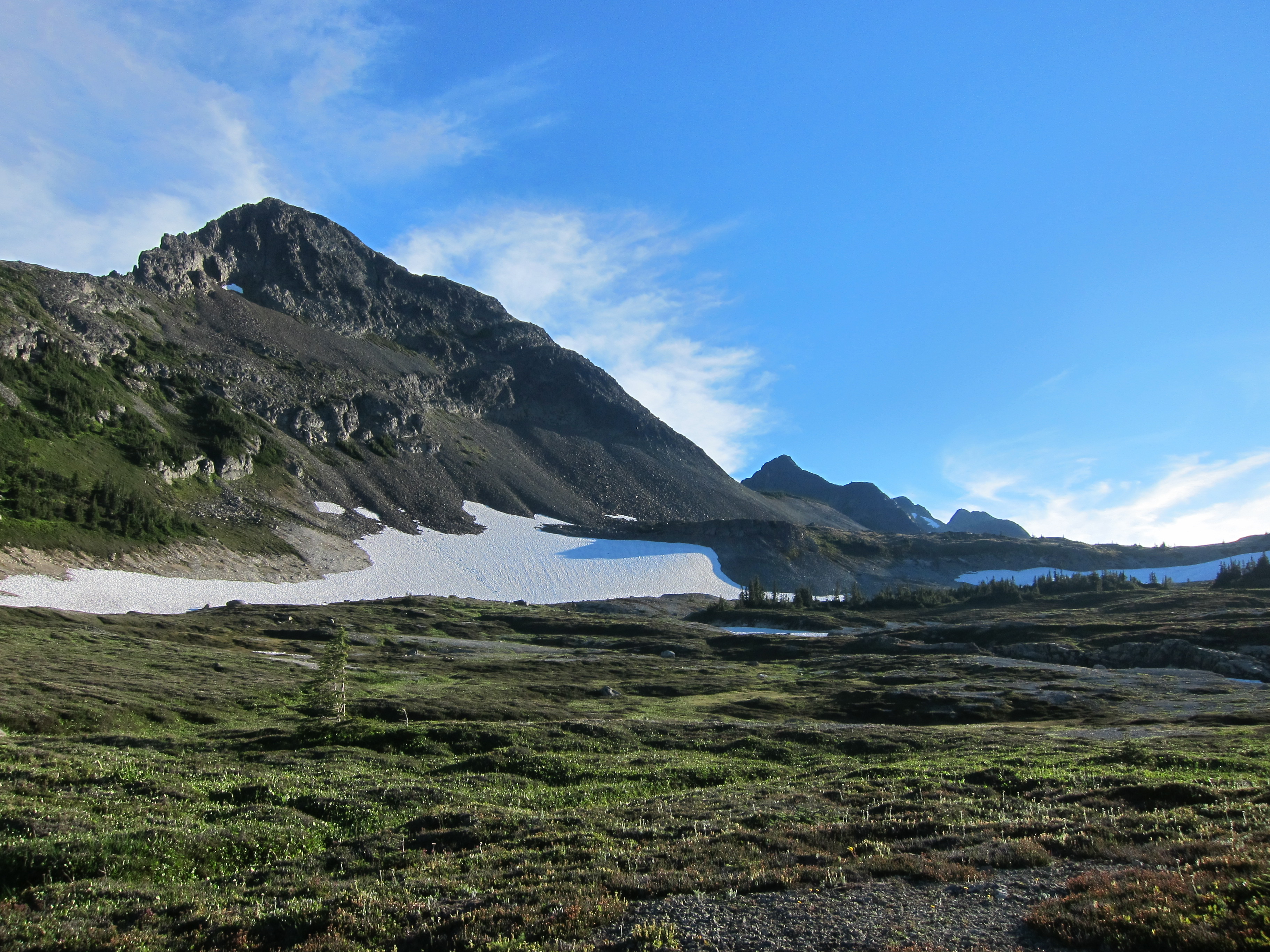
That we hit snow so low surprised us slightly given how warm the temperatures had been lately, but snow lingers easily down in the valleys and north facing slopes that this hike ascends.  It wasn’t contiguous immediately, but soon became reasonably deep and we had no footbed to follow most of the way up to Drum Lake, which we reached just before 1pm.  Here we stopped for lunch and then headed up the slopes to the right (West) of the lake, hitting the col due north of the summit of July Mountain and here made our only real routefinding error of the day.  Rather than heading up the easy snow slopes to the right of the ridge (which we would later descend), we instead scrambled up and left through an icy rock band to hit the ridge a good 10m earlier than we would have had we just followed the easy route.  Nonetheless, we persevered and made it up onto the ridge, upon which the travel is easy and we quickly made our way to the true summit of July Mountain, reaching it before 2pm, only around 45 minutes from the lake.

The views on the summit were fantastic and it was great to see the snowy wonderland all around us despite the temperatures hovering in the t-shirt range.  July Mountain is the highest peak for quite some distance and there were great views of the Anderson River Group, the area around Coquihalla Mountain, and even as far away as the Old Settler and Mt. Urquhart.

We lingered on the summit for half an hour before starting our descent, which was quick (only 30 minutes) down to the lake, and less than 2 hours from there down to the car.  Total round trip time was just over 6 hours, so the 103 hikes time estimate of “allow 6 hours” would be easy to achieve by any party moving at a moderate pace provided that they were able to drive to the trailhead.  In the end, I was very impressed by this hike.  The setting is fantastic, and the route varied and interesting.  In fact, it may well be one of my favourite hikes from 103 hikes.

Continue ReadingJuly Mountain

Coquihalla, Jim Kelly, and Illal

Trip Date: August 5-6

Participants: Max Bitel, Brittany Zenger, Ed Zenger, Geoff Zenger

Difficulty: 1 (Illal), 2 (Coquihalla), 3 (Jim Kelly)

Report: A long debate between the four participants over what an acceptable destination would be for everybody eventually led us to the idea of doing an overnight trip to Coquihalla Mountain.  Other than Ed, who climbed Coquihalla back in 1992, none of us had been to the area and we had heard that Illal Meadows was a great place to camp.

We didn’t leave Vancouver until early in the afternoon, and it wasn’t until 4:30 that we parked Ed’s X-Trail 1.5km up the Illal Creek road (out of a maximum of 3km) due to extreme bush.  Despite being late in the afternoon, the temperature was hovering around 30 degrees, and to avoid overheating, we moved slowly as we made our way up to Illal Meadows. The directions in 103 hikes are accurate and easy to follow, and we were up in the meadows by 6:30.  We bumped into two women camping low in the meadows, and they informed us that another party was camping at the tarn directly below Jim Kelly Peak, and so we elected to camp at a flat spot next to a creek along the east edge of the meadows.  A powerful warm wind blew over us all evening that kept the bugs away, and after a relaxing evening near the camp, settled in for a warm night under an incredibly bright moon.

We woke up Monday morning just after 6 and after breakfast, headed out for Coquihalla Mountain.  Ed had previously climbed the NE ridge, but as this was intended to be an easy hiking trip, without any major scrambling, we decided to head for the mellow South ridge of Coquihalla.  One major mix up had us bushwack through steep dense bush down from the ridge below Jim Kelly to the col between Jim Kelly and Coquihalla, only to realize at the bottom that there’s a well trod trail in good condition all the way down from the low point on the ridge between Jim Kelly and Illal down to the Coquihalla-Jim Kelly col.  Oh well.

Traversing around the east side of Coquihalla was straightforward, a mix of grass, talus, and occasionally patch of snow, and it didn’t take us long to find ourselves south of the main peak of Coquihalla, where we started ascending the obvious rib, occasionally finding bits of ribbon but never needing to think too hard about the route.  High up on the ridge, there is a short rubbly scrambling section if you go straight up the centre of the gully, but this can be avoided by ascending larger boulders to either the left or right of the gully.  Both Max and Ed’s watch altimeters indicated that we had about 500ft left before the summit, but at the top of the gully we found ourselves unexpectedly on the summit!  It was only around 10 o’clock, and we took our time to enjoy the warm air and clear views all around.

We all departed the summit around 11, and worked our way back towards Illal Meadows.  Max and I decided to head up Jim Kelly while Ed and Brittany went over to Illal Mountain.  From below, Jim Kelly looks like quite a formidable rubbly scramble, but as we made our way up it, we found that by moving left and right, we were able to avoid most of the rubble and never encountered any major difficulties.  It only took around 20 minutes to scramble up to the summit of Jim Kelly from the bench below the summit.  On the summit there is a massive fallen down cross, and we had our first glimpse of a dark thunderstorm to the south east of us, over in the direction of Manning Park.

Max and I were back down on the bench below Jim Kelly at 1:30, and I decided to make a quick solo trip over to Illal before the thunderstorms hit.  The round trip time from the bench to the summit of Illal, then down to our campsite was only 50 minutes, and as the storm was clearly approaching rapidly, we packed up camp quickly and began heading down around 3.

Not long after leaving camp, the unexpected storm hit, and we were drenched as we worked our way back to the car.  The descent took around an hour and a half, and we were all extremely grateful to have packed a change of clothes as we were all completely soaked!  Nonetheless, the trip itself was an absolute success, and can be highly recommended as a moderate trip off the beaten track.

Continue ReadingCoquihalla, Jim Kelly, and Illal

Great Bear Peak (Iago)

Trip Date: December 15, 2011

Participants: Brittany Zenger, Geoff Zenger, Nancy Zenger

Difficulty: 2

Elevation Gain: ~600m

Report: Back in Vancouver for a few weeks, and having taken an AST-1 course last winter, my sister Nancy was eager to try out a real ski tour for the first time, and so our objective for the day was to find a reasonably short day objective without any significant difficulties and that Brittany and I hadn’t already visited (thus ruling out the usual suspects for this situation, such as Zoa, Zupjok, Kelly, and Paul Ridge).  It took us the entire ride to Hope to all agree on a destination, but in the end decided on the minor peak referred to in Baldwin’s book as “Great Bear Peak” (note: Baldwin refers to the northern summit as “Iago” and the southern as “Great Bear”)

We arrived at the Zopkios Ridge rest area on the Coquihalla highway at around 9:30, where we bumped into the Baldwin clan, who were just starting out towards Zupjok peak, and geared up for our trip.  The first part of the route to Great Bear Peak is the same as that for Zupjok Peak, up into the basin between Zupjok and Ottomite peaks.  From the basin, the second portion of the route involves making a slightly ascending contour around Zupjok peak, eventually reaching the col between Zupjok and Iago peaks.  Here we stopped for a snack break, and after a short while, proceeded up the lightly treed ridge to Iago peak.  There are a couple of short steep sections on the ridge, but there isn’t any serious exposure, and so everyone managed to make it right to the summit without ever having to remove their skis.

We reached the “Iago” summit around 1:30, and from the summit of Iago, it looks like the “Great Bear” summit is either the same height or perhaps a couple of metres lower.  Regardless, as we were planning on returning via the ridge that we came from, it made no sense for us to drop down the 30m into the col between Great Bear and Iago, ascend the other summit, and then make our way back to the Iago summit.  The views would be the same from either summit.

Leaving the summit a bit past two, it was a quick ski down the ridge back down to the Zupjok-Iago col through surprisingly nice powder, and from there it was a simple matter of following our tracks back to the Ottomite-Zupjok basin and gliding down the road from there.  In all, a reasonable first ski tour for a beginner, but for anyone else, the peak is only suitable for completionists.  The views from Zupjok are better, the run down from Zupjok is better, and ascending/descending Zupjok does not necessitate contouring around Zupjok.  I’m glad I went out this way once to see what was there, but in the future, I’ll be sticking to Zupjok for a short winter ski day in the area.

Verdict: 1/3.  Nice enough, but there are a few superior ski tours starting from the same parking lot.


Continue ReadingGreat Bear Peak (Iago)