Williams Peak

Date: Aug 1, 2022

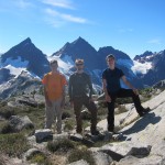
Participants: Nancy Zenger, Jeff Wallace, Geoff Zenger

Difficulty: 3 (very steep heather, some rock scrambling)

Report: Not to be confused with the Williams Peak above Bralorne that I climbed a decade ago, we decided to make the best of a hot long weekend day to make our way to the prominent Williams Peak in the Chilliwack Valley. It’s summit pyramid is unmissable as you drive towards Chilliwack Lake but somehow I’d never managed to make an attempt on it now, probably due to the massive elevation gain serving as a ready deterrent. Nonetheless…

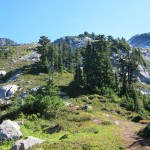
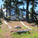
We set out from our car shortly before 10 and slogged our way up the steep trail and through the heat up to the ridge, which we reached in about 1:45. The heat made it feel slow, but someone had done some very recent trailwork and the trail is in excellent condition up to the ridge. Luckily the heat stayed down in the valley and we experienced much more reasonable temperatures higher up, though with the tradeoff. that there were a lot of bugs about in the forest.

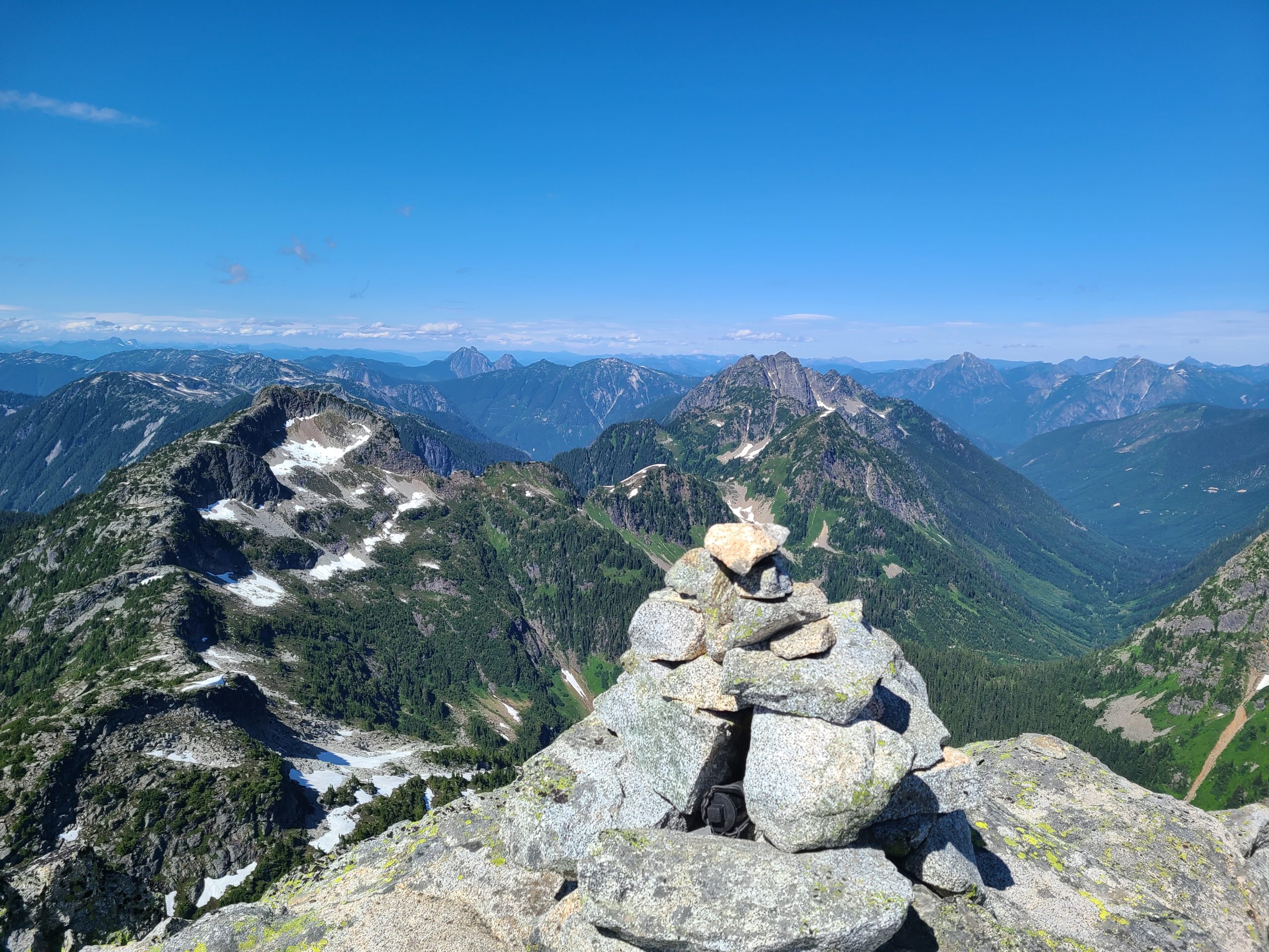
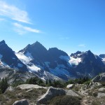
The trail along the ridge hadn’t seen recent work and was somewhat bushy in places, though never bad, and we quickly made our way up to the viewpoint at the end of the ridge, reaching it in just over an hour. Here we had lunch and decided on our route down and across the bowl towards the summit pyramid.

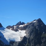
We began our descent into the bowl at 1:15, going straight down the obvious gully down to where there was a fairly obvious ledge heading to the left. From here we contoured across the bowl, following occasional flagging, and despite reports that it was an endless boulder-fest, actually found that the boulders weren’t bad at all and were able to do much of the traverse and ascent through the little heather and shrub forests that adorn the bowl.

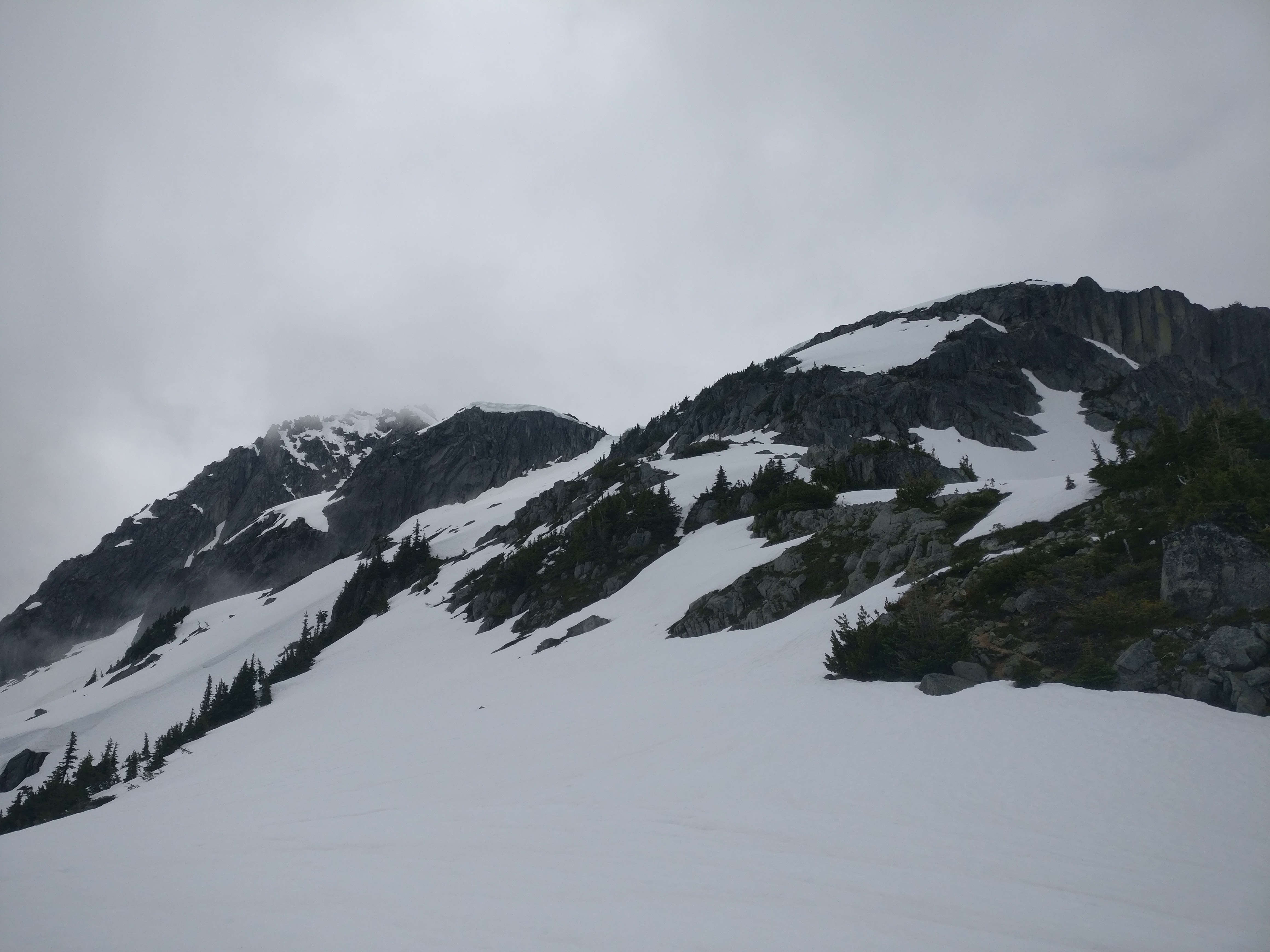
At the far end of the bowl is a nasty loose rock and boulder filled gully that Gunn calls a ramp. It is very loose with few solid holds, and at one point we reached a short section with almost nothing to hang on to and where everything was moving under us. Jeff made his way through it, but Nancy and I were sketched out and after losing a lot of time to indecision, I eventually elected to not proceed and rather to descent.

I started back down the ramp, and about 30 seconds into my descent decided that I should check out the heather slopes to climber’s left of the ramp. Sure enough, they are easy to walk up to the top and then traverse over to the top of the ramp. Approximately 3 minutes after giving up on the ramp and starting my descent I found myself safely on top of the ramp looking down on the others.

Long story short, don’t bother with the loose gully / ramp. Go up the heather to its left and skip the whole excitement.

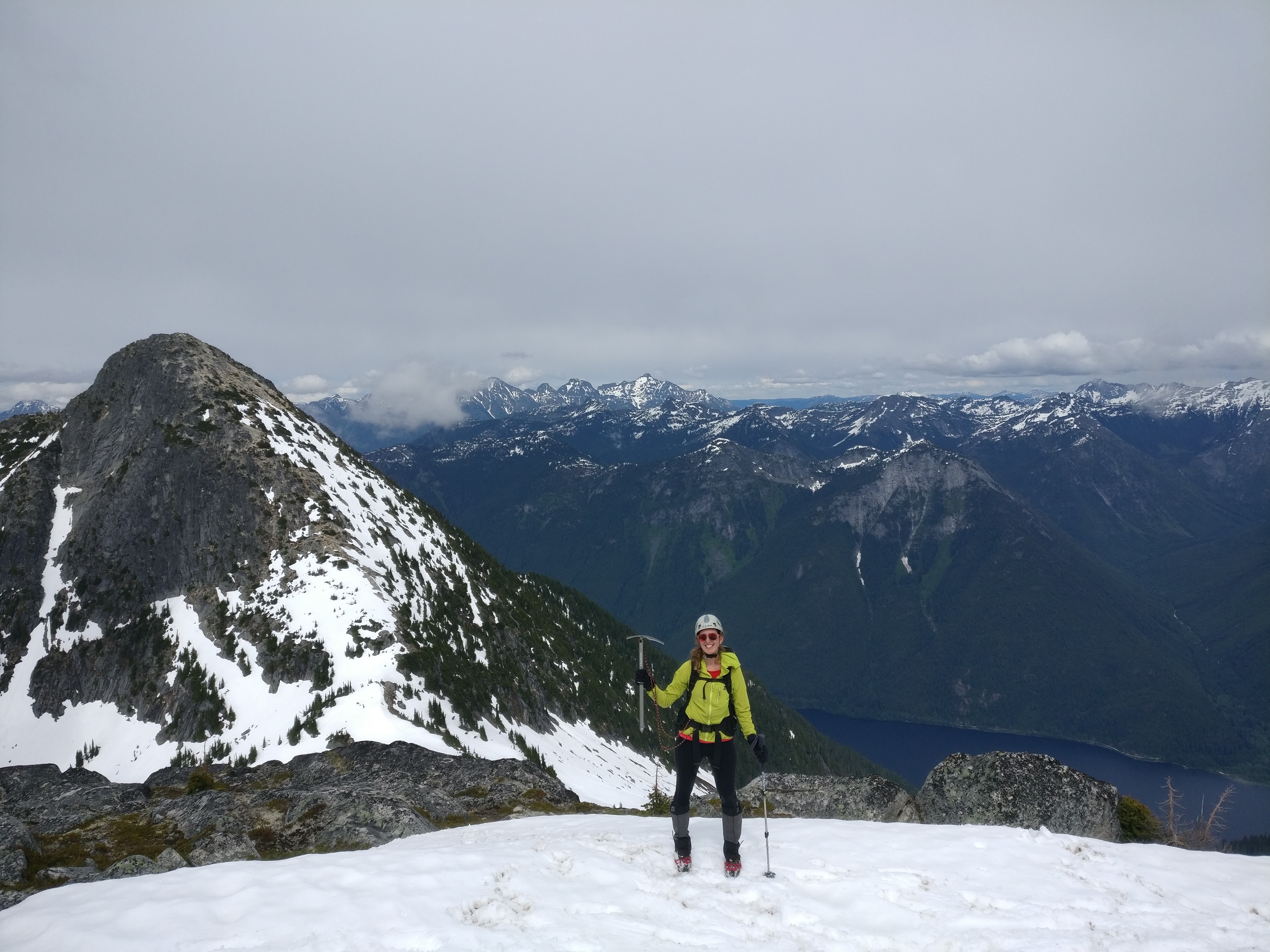
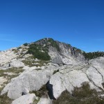
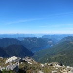
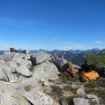
On top of the ramp at about 2:45 we stopped for a quick snack then worked our way around to the south of the pyramid where there is an obvious massive heather gully that leads right to the summit. The gully has no technical difficulty and only needs hands in a few short sections, but man is it steep. There are steps in the dirt in the most part from people who came before, and so it is no problem for the sure footed, but I know many people who would have zero interest or desire to make their way up and down the gully due to the steepness. That said, it is direct, and we were on the beautiful summit at 3:25pm. Perfect temperature and clear views all around!

We began our descent a few minutes before 4pm, were down below the ramp at 4:35, across the bowl and back at the ridge viewpoint at 5:10, at the junction of the ridge trail where the real descent begins at about 6:15, and down at the car at about 7:50 with no damage done except for a badly blistered toe from the descent.

Total elevation gain was somewhere between 1,700m and 2,000m depending on whose trackers we trust, 17.8km and a total round trip time (including breaks) of nearly 10 hours. A big day, but big views! Thank you for the adventure!

Continue ReadingWilliams Peak

Mt. Lindeman

Date: July 24, 2017

Participants: Ed Zenger, Geoff Zenger

Difficulty: 2

Report: Mt. Lindeman is the tallest peak immediately west of Chilliwack Lake, taller than Mt. Webb and Macdonald Peak, and until recently access involved either a long “class 5” bushwack up to Hanging Lake from the south end of Chilliwack Lake or a nearly 3000m day to go via Radium Lake and head up and over Macdonald Peak.  Lucky for us mortals, Harry and the Chilliwack Outdoors Club built a wonderful new trail to Mt. Lindeman last year!

The crux of the trip was finding the right place to park.  This isn’t because it’s not obvious, but rather that the directions to the trailhead that I found online and was following were simply wrong, and we wasted half an hour in the morning dinging up my car and exploring the wrong logging roads.  However, finding the trailhead is in fact easy.  Turn off the Chilliwack Lake Road at the signed turnoff for the Slesse Memorial Trail and cross the two small bridges over the Chilliwack River.  Reset your odometer as your turn off of Chilliwack Lake Road, and once over the bridges, turn left at the first junction (right heads up Nesakwatch Creek to the Slesse Memorial Trail trailhead).  The road parallels the river for close to 5km before turning right and heading up Centre Creek.  While driving up Centre Creek FSR, follow the most travelled road, staying low in the valley (i.e. to the right) and avoiding all roads turning off to the left.  Park at 10.2km from Chilliwack Lake Road, at a fork in the road.  At this point the east ridge of Rexford will be looming large above you.  The right hand fork is overgrown and not drivable, and this is the road you will be hiking up to start your hike.   The road to the left is the wrong way, and after switching back, goes up past many large waterbars to a recent clearcut.  Do not drive up this road.  Note that the road to the trailhead is in good shape, with only some minor ditches and could be reached in any 4wd vehicle, such as any little Subaru.

The first few kilometres of the route to Mt. Lindeman follow the overgrown road (the right-hand fork from the 10.2km parking) as it gently ascends beside Centre Creek until about 40 minutes later it reaches the creek coming down from the valley below Mt. Lindeman.  At this point you make a hard turn to the left, going past a metal sign reading “Mt. Lindeman trail”, and proceed to hike straight up the mountain for a few hundred metres.  This trail is well flagged and in great shape, and after easing up a bit, heads into the valley to the northwest of Mt. Lindeman, reaching some meadows.  We had started hiking just past 9:30am, and reached the meadows at around 11:10.  At the far end of the meadow the trail disappears when it reaches some large boulders, and we made the mistake of bushwacking through the boggy meadow to our left.  As we learned later, it is better to simply go through the large boulders en route to the main boulder gully that can be seen ahead.

Here we took a break and began our route up the main boulder gully (the right hand one) at around 11:30, and reached the main valley above about 40 minutes later.  From here the route is obvious to the col between the ascent valley and Upper Hanging Lake, which we reached just before 1 pm and here we sat down to eat lunch.  From this point, the goal is to make an ascending traverse across the basin to the steep grassy slopes heading up towards the summit.  We shortcutted across the snow to hit the grass and boulders on the far side of the basin, and while the slopes on the other side are steep, it is no problem to ascend them without getting into any 3rd class terrain.  The summit was reached at a bit past 2:15pm, for a total ascent time of a bit over 4.5 hours.

Mt. Lindeman might have the best views of any mountain near Vancouver.  From the summit there are clear views of Rexford, Slesse, Baker, Shuksan, Williams, Bear, Redoubt, the whole Cheam range, as well as the Pickets, Silvertip group, and usual peaks north of the Fraser Valley.

We hung out on the peak for quite a while to take it all in, and finally departed at around 3.  The descent was made very quick by glissading down snowslopes in the upper basins, followed by the excellent trail down to the valley.  The final few km down the overgrown road back to the car were sloggy and annoying, but nonetheless we made it to the car at 5:40pm, for a total descent time of a bit over 2.5 hours and a round trip time of 8 hours.  Note that we were moving pretty quick due to the late start and I would recommend allowing more than 8 hours for most parties.

I highly recommend Mt. Lindeman.  With the trail in its current shape it belongs in the list of top 10 SW BC hikes.  A must do!

Continue ReadingMt. Lindeman

Macdonald Peak & Mt. Webb

Date: June 17, 2017

Participants: Bill, Ilze, Ove, Miranda, Joseph, Oudi, Nancy Zenger, Geoff Zenger

Difficulty: 2/3 (steep snow)

Report: A couple weeks ago I found out that my scheduled BCMC trip to Ben Lomond wouldn’t be possible due to bush overgrowth on the Wind Lake trail from Furry Creek, and I needed to quickly select another destination for my trip.  A flip-through of Gunn’s Scrambles book suggested that Macdonald Peak and Mt. Webb in the Chilliwack Valley would make for a good trip destination at this time of year with the long days.  I haven’t been out on many long hikes lately, and I wasn’t sure how well I’d do on a 2000m day, but the forecast was good enough and decided to go for it.

Most of our carpool arrived at the Chilliwack Lake day-use area just before 8am, although one of our drivers missed the turn and drove part way around the lake before heading back to the proper parking area.  This delayed us somewhat, but we were able to start hiking at around 8:30, down the beach trail towards the bridge and over the Chilliwack River.  From the river crossing, it’s about a 2.5km walk downriver to the no longer existent bridge crossing mentioned in Gunn’s book, and another 500m up to the (well-signed) start of the Radium Lake trail.

The trail up to Radium Lake is long and quite uninteresting aside from the 3 creek crossings: one on a remarkable suspension bridge that would have been a huge effort to construct, one on a flattened log, and the other on a plain old footbridge.  We hustled up the trail without any significant breaks and reached the lake at 11:30 (parking to lake: 3 hours).  Miranda’s flight the previous evening had been significantly delayed and landed at 2:30am, so she elected to sleep on the tent platform by the lake while the rest of us went up to the peaks above.

The flagging indicating the trail up to the Macdonald-Webb col was not obvious to us from the tent platform, and so for the first 10 minutes above the lake we found ourselves bushwacking up the hill before stumbling across a perfectly good trail that we should have been on all along.  We hit snow just before the trail leaves the trees, and with good snow conditions were able to quickly kick steps up to the Macdonald-Webb col where we stopped for lunch and to put on our crampons (lake to col: just under 1 hour).

From the col, we could see that our route up Macdonald would be almost entirely on snow, whereas the south ridge of Webb was 99% snow free.  Macdonald being the larger peak, we decided to head there first, and quickly made our way up to the false summit on snow.  From here, Gunn’s book suggests scrambling up the north ridge, but there was a snow face just to the right of it that appeared to go nearly to the summit, so with our ice axes and crampons we kicked steps up the steep snow slope (~40-45 degrees at steepest point) until we hit rock just below the summit block.  Here we removed our crampons and it was a quick 5 minute scramble on to the summit, which we reached at about 2:05 (col to Macdonald summit: 1 hour, 20 minutes).  We relaxed on the summit for a while, taking in the views of Rexford as the clouds permitted, before starting our way down to the col, departing at around 2:30.

The initial descent was slow as we kicked steps back down the steep snow, but soon sped up and we headed back down to the col, stopping for another bite to eat.  It was getting late by the time we were ready to start our ascent of Webb and so we left our packs in the col, and hustled up the obvious south ridge of Webb as quickly as we could.  Joseph and I made it to the summit in 21 minutes from the col, and the last of us made it up in 30 minutes.  The views were much better from the summit of Webb than they were from Macdonald, so we stopped to take photos and enjoy the day, but eventually noticed it was 4:30 and that we’d need to hustle to make it back down.  The descent off of Webb was quick and easy, and snow made the descent down to Radium lake quick as well, and we reached the lake at 5:30 for our final major rest of the day.

Like so many other hikes in BC, the final stretch of this trip was a real slog and really not fun at all.  With tired legs the descent from Radium Lake to the Chilliwack River and then the ascent back to Chilliwack Lake and the parking lot seemed to go on forever, but we eventually reached our cars at about 8:20 (lake to parking: 2 hours, 35 minutes).

We were really lucky with the weather as it was great for efficient movement: high overcast all day, never raining and never hot.  As a final note, I would not recommend that anyone ever choose to hike just to Radium Lake.  It’s not a particularly nice lake, and you can’t see much of anything above it.  If you want to go to Radium Lake, I would strongly recommend that you follow the trail up to the Macdonald-Webb col, where the great views start, or even ascent all the way up to Mt. Webb.  Thanks to everyone for coming out with me.  I got to summit two new peaks, and had a great day!

Continue ReadingMacdonald Peak & Mt. Webb

Flora Peak

Date: Feb 25, 2017

Participants: Nancy Zenger, Jeff Wallace, Nathan, Geoff Zenger

Difficulty: 2

Report: A friend of mine skiied Flora peak in the Chilliwack valley a few years ago and said that it was a great ski trip, with easy access, nice fall line skiing, great views, and low avalanche hazard, and it’s been on my to do list ever since.  We all met at my house Saturday morning and set off down Highway 1, heading east, but with no particular destination in mind.  By the time we passed through Chilliwack, the sun in Coquitlam had given way to dense cloud, and we seemed to have settled on heading for a mellow day in the Coquihalla, perhaps skiing Zupjok and Iago when Nancy finally made the executive decision that we would try going somewhere new.  The drive BC webcam near Chilliwack Lake showed snow next to the road, and as we were still in the final outskirts of Chilliwack, we made a brief backtrack and headed down Chilliwack valley to the Post creek trailhead.

Indeed, there was snow next to the road at the Post creek trailhead, and the parking lot was also covered in snow.  However, despite being at 630m, the trees appeared to only have a bit of snow in them so we strapped our skis to our packs and at 9:30 began our hike up the Flora Lake trail.  The trail is in good shape, and we quickly ascended.  Little did we know that it would be a long hike up to find snow.  The trail ascends the southern slopes of Flora peak, reaching a camp/viewpoint at around 1200m that overlooks Chilliwack Lake.  Here we saw our first snow, and if it was a good snow year, from here you could skin directly up the mountain, but we elected to continue on foot, eventually reaching an open bench around 1600m.  This is where the winter route diverges from the summer route, with the summer route continuing ahead up the basin ahead to the col to the east of Flora Peak.  The winter route ascends the ridge above directly towards the summit.

We continued for about another 100m before finally electing to put our skis on around 1700m.  Finally!  From here the route is generally straightforward except for one point about 3/4 of the way up the ridge where the ridge steepens.  We kept on the ridge for as long as we could, and just below the rocks, skirted right onto the steep and mildly sketchy snow slope before reaching the comforting safety of the mellow slopes above.  From here it is easy to ascend directly to the summit.

We reached the summit at 1:30, and within a minute or two, so had a large cloud.  Engulfed in fog, the temperature plummeted and after a quick snack we started our descent in a thorough whiteout just before 2 o’clock.  The fog was dense enough that it was challenging to make out the skin track and we descended very slowly.  Only a minute or two down from the summit, Jeff called out from the back for us to wait up.  One of his skis had snapped!  Despite descending through the whiteout at a snails pace, apparently a gentle dip in the slope was all that it took to cause his new G3’s to snap about 8 inches ahead of the front binding.

Nancy volunteered to carry the broken ski, and Jeff soldiered on, skiing and side slipping down the mountain on just one ski.  Nate and I had a surprisingly good run down to the flat spot at the bottom of the basin, and amazingly, the others were only slightly behind us.  From here, rather than follow the trail we skiied straight down the mountain, and managed to hit the trail just a couple minutes walk from the 1200m viewpoint.  The trees on the descent to this point are quite open and in a good snow year would make for fantastic gladed skiing.  For us, they weren’t great, but had just enough snow to allow us to make it down to this point without significant difficulty.  From the viewpoint, the skis were put back on our packs and we hustled down the trail, reaching the car just before 4, for a total round trip of 7.5 hours.

In the right conditions, Flora Peak could be a great ski trip, but in present conditions it would have been more suitable for snowshoes.  Nonetheless, it was great to get out with good company and ski in an area I hadn’t visited before in winter.

Continue ReadingFlora Peak

Conway Peak

Date: Sept 13, 2014

Participants: Jean-Michel, Julie, Geoff Zenger

Difficulty: 2

Report: Originally intended as an overnight BCMC trip to Stoyoma Mountain and Mount Hewitt Bostock in the northern Coquihalla region, a change of plans and need to be back in Vancouver on Sunday meant that the trip had to be shortened to a day trip.  Opting against driving all the way through Merritt for a day trip, we changed our minds in Chilliwack and headed up Conway Peak, the southernmost peak in the Cheam range.

The road up to Jones Lake and then to the trailhead is in decent shape right now, but definitely requires a 4×4 HC vehicle.  We arrived at the trailhead at around 10 and started our way up the trail at about a quarter past, making our way up the switchbacks on an old road.  The road here is quite overgrown in places, but easy to follow, although we missed the 4th switchback and instead of making the turn right before a creek crossing, we hopped across the creek and continued about 15 minutes right to the end of some even older spur, wasting a good half hour of our time.

Once back across the creek where the switchback should’ve been it was easy to see where the right way to go was, and a few minutes later we entered the old growth forest to follow the old Lucky Four Trail up to Mile High Camp.  This trail is in great condition and is very pleasant.  Just before 1 o’clock we found ourselves getting hungry and decided to stop at the next knoll, and were happy to find that it was indeed the famed mile high camp!  It’d be a great spot to camp with fantastic views all around, although I personally wouldn’t really want to lug an overnight pack all the way up there…

We left the camp at 1:35, and from here the route up Conway is really nice over open heather and rock slopes, and it was easy and fun to make it up to the summit, which we reached at 2:20, 45 minutes after leaving the camp.  Total ascent time, 4 hours, including 35 minutes at mile high camp and 30 minutes on the wrong road.

We had lucked out and had amazing fall weather on the summit, warm, sunny, and clear.  We dozed off for a while, took group shots, gazed at the huge north faces of Foley and Welch, and identified peaks south of the border for nearly an hour before starting back down.

The descent was quick and uneventful and took under 2.5 hours to complete.  Total round trip time was around 7.5 hours.  In all, Conway Peak greatly exceeded my expectations and is a really nice hiking peak that doesn’t see the popularity it deserves.  Great views, nice trail (minus the bottom bit), close to Vancouver.  Recommended!

Continue ReadingConway Peak