Hector Ferguson Lake

Date: August 27, 2017

Participants: Nancy Zenger, Jeff Wallace, Geoff Zenger

Difficulty: 1

Report:  Hector Ferguson Lake is certainly the most notorious of the 103 hikes, not least because its published roundtrip distance of 28km is a gross misunderestimation by any measure and also because of its crossing of Gold Creek.  Nonetheless, as an aspiring completionist, it was finally time to head to the infamous lake.

I posted a trip on the BCMC schedule and failed to find any takers, but managed to convince Nancy and Jeff to come along with the promise that they would make a 7pm dinner in town.  This seemed overly ambitious given that we weren’t going to be able to have a very early start and I managed to dig up a trip report alleging a 13.5 hour round trip time, but nonetheless decided to take advantage of the opportunity and have a go at the lake.  To my surprise, aside from a couple km of nearly destroyed trail on either side of the Gold Creek crossing, it’s quite a pleasant trip!

I was picked up in the morning just past 7, and this meant that we were able to be parked at the East Canyon lot in Golden Ears Park and on the trail at a few minutes past 8.  We brought our bikes and aside from being a bit grunty in short sections, had no difficulty making good time up the East Canyon trail.  We passed Viewpoint beach and at about 5.75km stashed our bikes in the bush beside the trail, a couple hundred metres past where the trail ceased to be reasonable for biking.  Total biking time was a bit over an hour, perhaps around 1:10-1:15.

From where we hid the bikes in the bush, the trail is in great shape (with minor exceptions) until past the 10km marker.  However, there is a certain point around 10.5km where the trail rapidly deteriorates.  Soon after becoming bushy, the trail is just above the creek and there is some flagging leading down to it as well as flagging leading straight ahead.  We tried following the trail above the creek, but it’s terrible and quickly backtracked and went down to the creek, following it to a sandbar where the river makes a hard turn to hiker’s left.  This is the only point where the route was not obvious.  You’ll see the trail above the creek descending down to you on your right, but continue straight ahead into the bush to find flagging and a continuation of the trail to the crossing over Gold Creek.

This is where the trail is simply destroyed.  It is only a few hundred metres, but trees have fallen over left, right, and centre.  With a bit of creativity though it was possible to stay on top of many of the trees and make our way across the mess, through a few minutes of badly overgrown trail, and pop out onto the beach just 50m downstream of where you need to cross Gold Creek.  Look for the obvious flagging on the far side of the creek.  I crossed the creek on some logs about 50m downstream of the flagging, and Nancy and Jeff simply took off their shoes and waded through the slightly-above-ankle deep water to the far side.  Total time from car to Gold Creek crossing: 2 hours, 15 minutes.

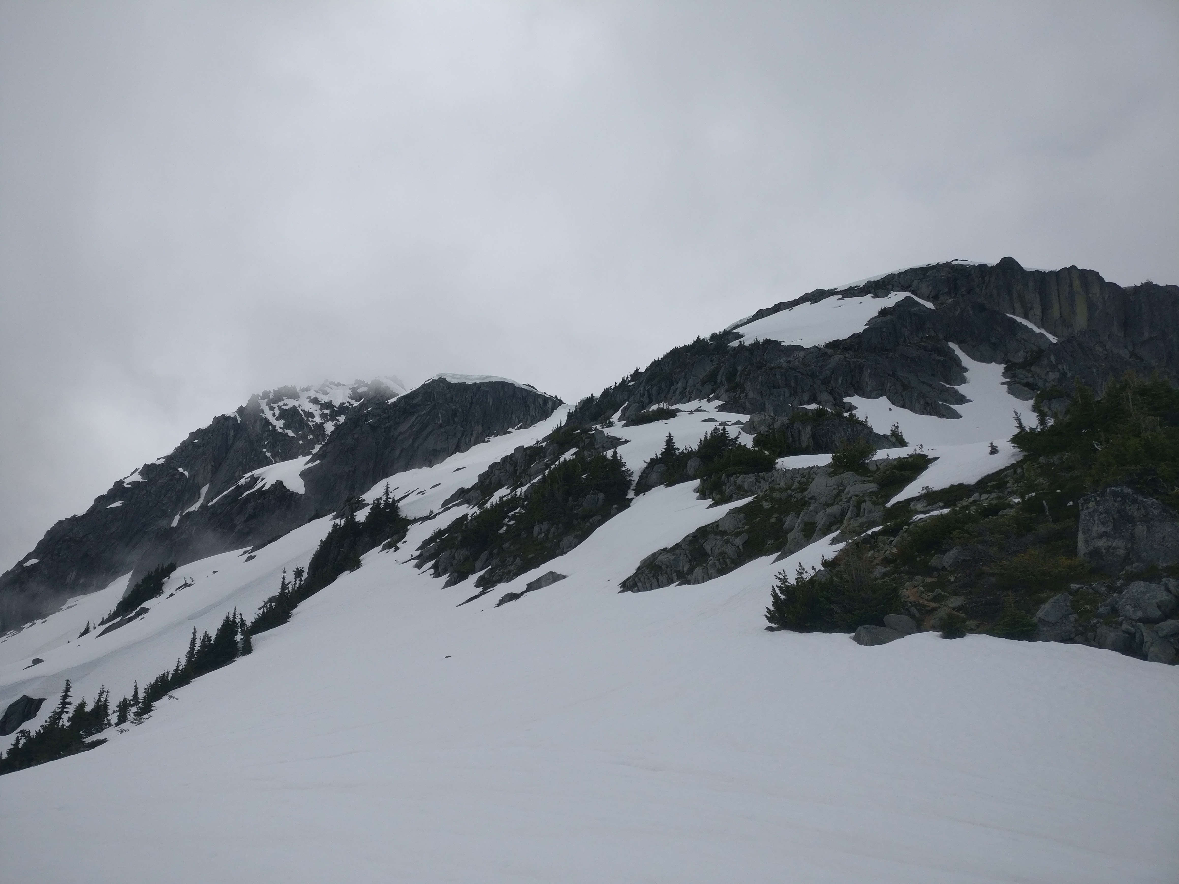
From the far side of Gold Creek, the trail heads through the bush for a few minutes to the easy crossing over Hector Ferguson Creek, and continues through blow down and berry bushes as it starts its ascent towards Hector Ferguson Lake.  At first the trail is in quite bad shape, but after a short while becomes much better.  The trail is extremely well flagged, and while not too quick due to all of the branch dodging and occasional bushy section, was easy enough to follow all the way up to Hector Ferguson Lake.  Total time to lake: 4 hours, 15 minutes.

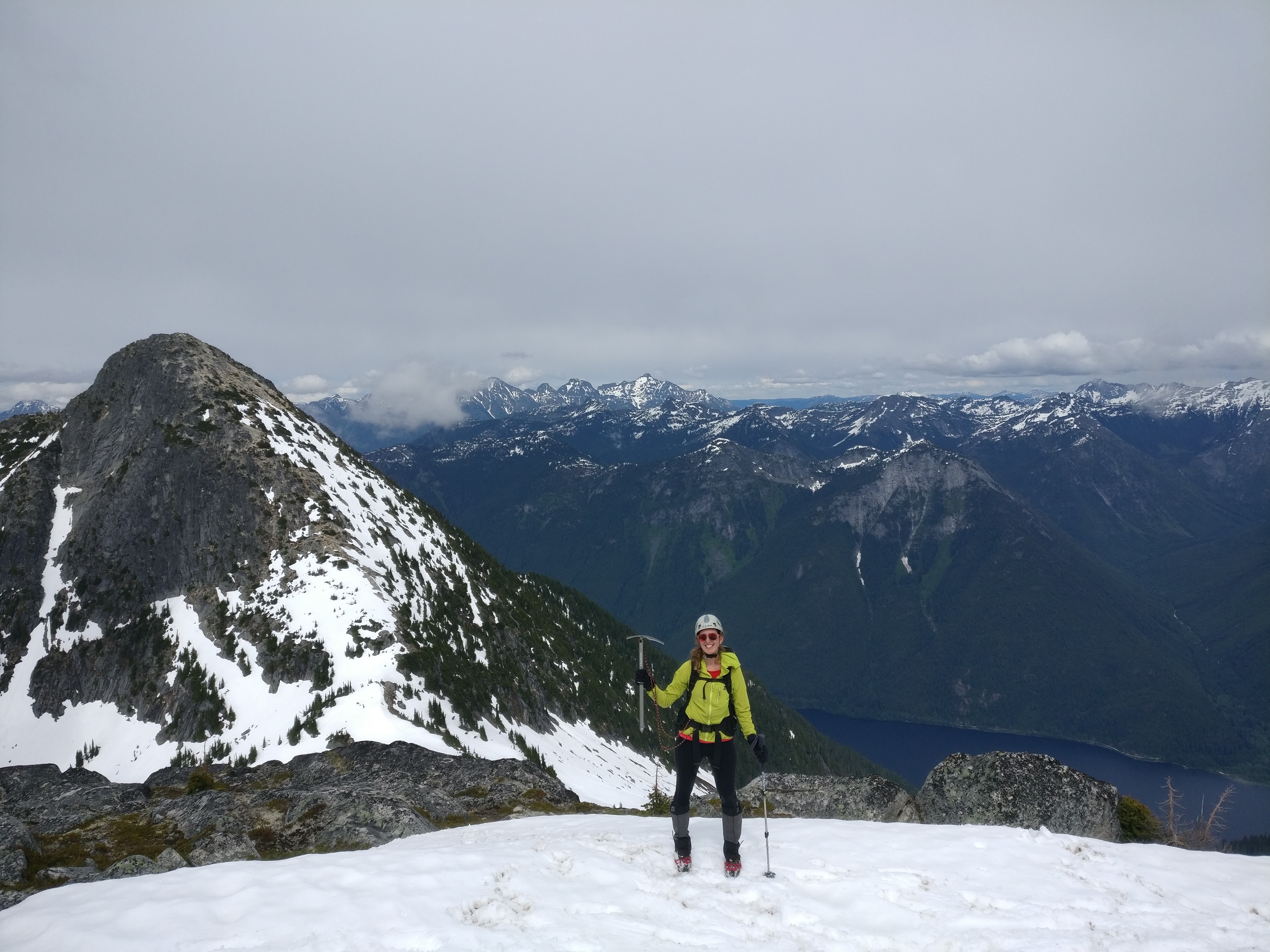
I was so happy to be there!  At last, Hector Ferguson Lake!  The lake itself isn’t anything special, just any other lake in the mountain, but it’s pleasant enough and we had a good lunch before starting our descent.

Our descent from Hector Ferguson Lake to Gold Creek was as slow as our ascent.  I attributed this to a remarkable drop in our enthusiasm, but after a refreshing foot and leg dip in Gold Creek we felt rejuvenated enough to head back down the East Canyon Trail to the parking lot.  It took us almost an hour and a half back to our bikes, but other than the initial hill climb just past the East/West Canyon trails connector bridge, the trail is entirely downhill to the cars and we made it back to our car at a quarter to 5.  Total time from lake to parking lot: 4 hours, 9 minutes.

In the end, I enjoyed the trip a lot more than I expected I would.  It’s close to town, features a lot of pleasant and varied terrain, and was a rather nice way to spend a hot day near the city.  The bikes helped a lot, and allowed us to do the round trip in less than 9 hours, moving quickly but never racing (speed at getting over small logs a big plus).  The only real problem with the trail is the amount of bush that is encroaching on it.  The good news is that it’s 99% minor bush, and if a couple parties were to do the round trip with shears in their hands, just clipping away as they travelled up and down, the trail would quickly be in pretty good shape again.  If you’re thinking of heading in, maybe bring some with you and help out your fellow hikers!

Note: For comfort, recommended to bring a GPS track of the trail with you.  The GPS track on open street map of the east canyon trail is complete and appeared to be accurate.

Continue ReadingHector Ferguson Lake

Cathedral Park 2017

Date: July 28-31, 2017

Participants: Eira Zenger, Brittany Zenger, Geoff Zenger, Ed Zenger, Leslie Zenger, Peter Zenger, Nancy Zenger, Jeff Wallace

Difficulty: 1-3

Report: Ever since Brittany and I climbed the Matriach-Macabre-Grimface traverse from Wall Creek back in 2013 I had the idea in my head to book a cabin at Cathedral Lakes Lodge for the whole extended family and explore the core part of Cathedral Park.  Earlier this year, Brittany and I finally got our act together and pulled the trigger to organize a 4 day trip into the park.

We all met on the night of the 27th at a Keremeos campground so that we wouldn’t have to drive too far the next morning to meet our 10am ride from Cathedral Lakes base camp up to the lodge compound at Quiniscoe Lake, and after a poor night’s sleep due to the sun waking Eira at 4:45am, we drove down Ashnola Creek road to meet our ride in.  Lucky for us, as we were going to be staying in Tom’s cabin, which is a few minutes walk above the lodge we all got to ride in a comfortable Suburban rather than the dusty Unimog with the other campers that morning.  The ride in takes about an hour and was made enjoyable by our driver, Ernie, and by noon we had all our belongings in the cabin and sat down for lunch.

Now, this is my largely my fault for not doing research beforehand, but I had no idea how nice the cabin was going to be.  We had a 4 bedroom cabin with sheets and sleeping room for 8 people, running hot water, as well as a stove and fridge!  True luxury!

As we ate lunch the valley filled with smoke from a fire burning south of the border in the Paysayten Wilderness, and Peter developed a fever that would stay with him for the next 4 days.  However, I was motivated to make it up all the remaining scrambles in the park and convinced my dad, Nancy, and Jeff to head out with me in the smoke to climb the east ridge of Pyramid Mountain.  This is a fun and easy half-day scramble from Quiniscoe Lake.  There is no exposure on the route and we made it to the summit in roughly 2 hours from the lake.  By the time we reached the summit, the smoke had started to subside, and from the summit we rambled along the ridge to Devil’s Woodpile, and down to the col to the south of Quiniscoe Peak.  From here, Jeff and I decided to take the long way back via Quiniscoe Mountain and Red Mountain while the others descended directly to Quiniscoe Lake.  Total round trip time for Jeff and I was about 4.5 hours.

The following day, all of us except Peter headed up to Lakeview Mountain via the Centennial Trail (note: this is not the route indicated in Gunn’s book.  We used that route for the descent).  The smoke had cleared completely by morning, and although it’s very heavy to carry an 18 month old baby all day, we shared the load around and ascended through wonderful meadows on the long gentle climb to Lakeview Mountain.  All day we could see the thick smoke to our south but it never quite encroached on us or severely diminished our views.  From the summit, everyone except for Nancy, Jeff, and I decided to head back down the way we ascended, but the 3 of us descended the south ridge of Lakeview on a good trail and made a quick jaunt up to the summit of Boxcar mountain.  From here we faced a decision of whether to return to the Lakeview-Boxcar col and follow the trail from there down to Goat Lake, or whether to continue to the south and head up Denture Ridge before descending to Goat Lake.  In the end, the decision was simple to head directly down as the smoke was starting to close in, and I found myself as able to justify not going up Denture Ridge because of how close to its high point I’d been on aforementioned trip to Matriarch.  The descent to Goat Lake was quick, and we caught up to the rest of the group not far past the Goat Lake – Centennial Trail junction, at which point I resumed my baby carrying duties.

On the Sunday, Peter was feeling well enough in the morning to join us for the beginning of our hike.  The goal was to make a circle, heading to Glacier Lake, then to Stone City, Smokey the Bear, the Giant Cleft, and then down via the Ladyslipper Lake trail and back to the cabin.  Peter and Leslie only made it as far as Glacier Lake before returning to the cabin on account of illness, but the rest of us continued upwards and made the full loop as described.  Smokey the Bear was worth checking out, but I wouldn’t really recommend people go check out the Giant Cleft.  It’s a neat formation, but if you’ve spent time in the mountains you’ve seen similar features before and visiting it requires significant elevation loss from Smokey the Bear.  In all, the loop took us nearly 7 hours.

For our final day, a few of us hiked around the lakes near the cabin, and spent the midday rowing boats around Quiniscoe Lake, although both my mom and dad chose to hike the Diamond Loop trail, which apparently has the best flower meadows of any trail in the core park.  After this, we packed up and caught our scheduled ride back down to our cars.  On the way out we stopped as usual at Benji Thai in Keremeos, and then had a terribly long drive home because a logging truck had dumped logs all over highway 3 near Manning Park and we were detoured from Princeton to Merritt in order to drive the Coquihalla to get back home to the Lower Mainland.  Oh well.

In all, this was a terrific trip, and I am very grateful that my whole family was able to join our experience.  The cabin exceeded all my expectations and the staff of the lodge were friendly and very helpful.  Highly recommended for everyone!

Continue ReadingCathedral Park 2017

Mt. Lindeman

Date: July 24, 2017

Participants: Ed Zenger, Geoff Zenger

Difficulty: 2

Report: Mt. Lindeman is the tallest peak immediately west of Chilliwack Lake, taller than Mt. Webb and Macdonald Peak, and until recently access involved either a long “class 5” bushwack up to Hanging Lake from the south end of Chilliwack Lake or a nearly 3000m day to go via Radium Lake and head up and over Macdonald Peak.  Lucky for us mortals, Harry and the Chilliwack Outdoors Club built a wonderful new trail to Mt. Lindeman last year!

The crux of the trip was finding the right place to park.  This isn’t because it’s not obvious, but rather that the directions to the trailhead that I found online and was following were simply wrong, and we wasted half an hour in the morning dinging up my car and exploring the wrong logging roads.  However, finding the trailhead is in fact easy.  Turn off the Chilliwack Lake Road at the signed turnoff for the Slesse Memorial Trail and cross the two small bridges over the Chilliwack River.  Reset your odometer as your turn off of Chilliwack Lake Road, and once over the bridges, turn left at the first junction (right heads up Nesakwatch Creek to the Slesse Memorial Trail trailhead).  The road parallels the river for close to 5km before turning right and heading up Centre Creek.  While driving up Centre Creek FSR, follow the most travelled road, staying low in the valley (i.e. to the right) and avoiding all roads turning off to the left.  Park at 10.2km from Chilliwack Lake Road, at a fork in the road.  At this point the east ridge of Rexford will be looming large above you.  The right hand fork is overgrown and not drivable, and this is the road you will be hiking up to start your hike.   The road to the left is the wrong way, and after switching back, goes up past many large waterbars to a recent clearcut.  Do not drive up this road.  Note that the road to the trailhead is in good shape, with only some minor ditches and could be reached in any 4wd vehicle, such as any little Subaru.

The first few kilometres of the route to Mt. Lindeman follow the overgrown road (the right-hand fork from the 10.2km parking) as it gently ascends beside Centre Creek until about 40 minutes later it reaches the creek coming down from the valley below Mt. Lindeman.  At this point you make a hard turn to the left, going past a metal sign reading “Mt. Lindeman trail”, and proceed to hike straight up the mountain for a few hundred metres.  This trail is well flagged and in great shape, and after easing up a bit, heads into the valley to the northwest of Mt. Lindeman, reaching some meadows.  We had started hiking just past 9:30am, and reached the meadows at around 11:10.  At the far end of the meadow the trail disappears when it reaches some large boulders, and we made the mistake of bushwacking through the boggy meadow to our left.  As we learned later, it is better to simply go through the large boulders en route to the main boulder gully that can be seen ahead.

Here we took a break and began our route up the main boulder gully (the right hand one) at around 11:30, and reached the main valley above about 40 minutes later.  From here the route is obvious to the col between the ascent valley and Upper Hanging Lake, which we reached just before 1 pm and here we sat down to eat lunch.  From this point, the goal is to make an ascending traverse across the basin to the steep grassy slopes heading up towards the summit.  We shortcutted across the snow to hit the grass and boulders on the far side of the basin, and while the slopes on the other side are steep, it is no problem to ascend them without getting into any 3rd class terrain.  The summit was reached at a bit past 2:15pm, for a total ascent time of a bit over 4.5 hours.

Mt. Lindeman might have the best views of any mountain near Vancouver.  From the summit there are clear views of Rexford, Slesse, Baker, Shuksan, Williams, Bear, Redoubt, the whole Cheam range, as well as the Pickets, Silvertip group, and usual peaks north of the Fraser Valley.

We hung out on the peak for quite a while to take it all in, and finally departed at around 3.  The descent was made very quick by glissading down snowslopes in the upper basins, followed by the excellent trail down to the valley.  The final few km down the overgrown road back to the car were sloggy and annoying, but nonetheless we made it to the car at 5:40pm, for a total descent time of a bit over 2.5 hours and a round trip time of 8 hours.  Note that we were moving pretty quick due to the late start and I would recommend allowing more than 8 hours for most parties.

I highly recommend Mt. Lindeman.  With the trail in its current shape it belongs in the list of top 10 SW BC hikes.  A must do!

Continue ReadingMt. Lindeman

Deeks Peak (2017)

Date: July 8, 2017

Participants: Brittany Zenger, Geoff Zenger

Difficulty: 2

Report: Brittany, Eira, and I arrived home a day earlier than expected from Hornby Island, and with great looking weather coming the following day, we decided to have a go at Deeks peak.  I had a failed attempt of Deeks on skis back in December and I was eager for the opportunity to deal with unfinished business.

Much like last year when heading to Mt. Hanover, we drove up the Deeks road for ~3.2km to just before the final steep rise on the road and parked here so as to not destroy the XTerra on the final stretch of road.  The road seemed to be in even worse shape than last year and it’s getting to the point where I might just give in and park by the highway the next time I head up towards Deeks Lake.

We left the car at 8:25 and started our march up towards Deeks.  About half an hour up the Deeks lake trail there is a marker on a tree pointing towards the “Bypass trail”, and this is the route we chose for our ascent.  The “bypass trail” (aka “Deeks direct”, aka “Deeks W Ridge direct”) is the most direct trail up to the summit of Deeks but is in need of some love and care.  There are a few places on the trail where we were left hunting around wondering where the next ribbon was, but for the most part it is obvious enough to follow.  The only point with real confusion was where the trail popped out onto a boulder field and it wasn’t obvious that the trail continued to directly up and to the right without ever crossing the boulders.  That said, with a bit of work, I could see this trail becoming very popular as it really is a fantastic route.

As the trail nears treeline it became increasingly steep, overgrown and buggy, but by noon we were clear from the trees, and although we lost the trail markers we headed up straight for the summit without any difficulties, and were on top by 12:45.  The air was clear and the views were great, so we stopped for a lunch and to ponder our way down, eventually deciding to descend towards the Deeks-Windsor col to find the regular trail down to Deeks Lake.

We started our descent at 1:30 and quickly discovered that the route down the east side of Deeks (towards the Deeks-Windsor) col is steep, not travelled very often, and hard to follow with occasional snow patches obscuring the footbed.  Nonetheless, we managed to follow the route all the way to the final bump above the col, where we lost it.  Unfortunately we turned off the ridge too early and instead of going up and over the final minor bump we turned to our right and worked our way down a very steep, unpleasant, and precarious bushy slope until we found the flagging from the proper trail from Deeks joining us from the left.  From here it was just a couple minutes walk to meet the main trail heading up to Windsor.  Unlike the Deeks trail, this trail was in fine condition and we were able to make our way down to Deeks Lake, where we arrived at 3:45 and stopped for our final snack of the day.

From Deeks Lake it was the familiar old slog down to the car, which we reached at 5:15 for a total round trip time of just under 9 hours.  As it stands now, I wouldn’t recommend Deeks over the other peaks in the area like Brunswick or Harvey, but with a bit of work on the bypass trail, Deeks could once again be a north shore classic.


Continue ReadingDeeks Peak (2017)

Macdonald Peak & Mt. Webb

Date: June 17, 2017

Participants: Bill, Ilze, Ove, Miranda, Joseph, Oudi, Nancy Zenger, Geoff Zenger

Difficulty: 2/3 (steep snow)

Report: A couple weeks ago I found out that my scheduled BCMC trip to Ben Lomond wouldn’t be possible due to bush overgrowth on the Wind Lake trail from Furry Creek, and I needed to quickly select another destination for my trip.  A flip-through of Gunn’s Scrambles book suggested that Macdonald Peak and Mt. Webb in the Chilliwack Valley would make for a good trip destination at this time of year with the long days.  I haven’t been out on many long hikes lately, and I wasn’t sure how well I’d do on a 2000m day, but the forecast was good enough and decided to go for it.

Most of our carpool arrived at the Chilliwack Lake day-use area just before 8am, although one of our drivers missed the turn and drove part way around the lake before heading back to the proper parking area.  This delayed us somewhat, but we were able to start hiking at around 8:30, down the beach trail towards the bridge and over the Chilliwack River.  From the river crossing, it’s about a 2.5km walk downriver to the no longer existent bridge crossing mentioned in Gunn’s book, and another 500m up to the (well-signed) start of the Radium Lake trail.

The trail up to Radium Lake is long and quite uninteresting aside from the 3 creek crossings: one on a remarkable suspension bridge that would have been a huge effort to construct, one on a flattened log, and the other on a plain old footbridge.  We hustled up the trail without any significant breaks and reached the lake at 11:30 (parking to lake: 3 hours).  Miranda’s flight the previous evening had been significantly delayed and landed at 2:30am, so she elected to sleep on the tent platform by the lake while the rest of us went up to the peaks above.

The flagging indicating the trail up to the Macdonald-Webb col was not obvious to us from the tent platform, and so for the first 10 minutes above the lake we found ourselves bushwacking up the hill before stumbling across a perfectly good trail that we should have been on all along.  We hit snow just before the trail leaves the trees, and with good snow conditions were able to quickly kick steps up to the Macdonald-Webb col where we stopped for lunch and to put on our crampons (lake to col: just under 1 hour).

From the col, we could see that our route up Macdonald would be almost entirely on snow, whereas the south ridge of Webb was 99% snow free.  Macdonald being the larger peak, we decided to head there first, and quickly made our way up to the false summit on snow.  From here, Gunn’s book suggests scrambling up the north ridge, but there was a snow face just to the right of it that appeared to go nearly to the summit, so with our ice axes and crampons we kicked steps up the steep snow slope (~40-45 degrees at steepest point) until we hit rock just below the summit block.  Here we removed our crampons and it was a quick 5 minute scramble on to the summit, which we reached at about 2:05 (col to Macdonald summit: 1 hour, 20 minutes).  We relaxed on the summit for a while, taking in the views of Rexford as the clouds permitted, before starting our way down to the col, departing at around 2:30.

The initial descent was slow as we kicked steps back down the steep snow, but soon sped up and we headed back down to the col, stopping for another bite to eat.  It was getting late by the time we were ready to start our ascent of Webb and so we left our packs in the col, and hustled up the obvious south ridge of Webb as quickly as we could.  Joseph and I made it to the summit in 21 minutes from the col, and the last of us made it up in 30 minutes.  The views were much better from the summit of Webb than they were from Macdonald, so we stopped to take photos and enjoy the day, but eventually noticed it was 4:30 and that we’d need to hustle to make it back down.  The descent off of Webb was quick and easy, and snow made the descent down to Radium lake quick as well, and we reached the lake at 5:30 for our final major rest of the day.

Like so many other hikes in BC, the final stretch of this trip was a real slog and really not fun at all.  With tired legs the descent from Radium Lake to the Chilliwack River and then the ascent back to Chilliwack Lake and the parking lot seemed to go on forever, but we eventually reached our cars at about 8:20 (lake to parking: 2 hours, 35 minutes).

We were really lucky with the weather as it was great for efficient movement: high overcast all day, never raining and never hot.  As a final note, I would not recommend that anyone ever choose to hike just to Radium Lake.  It’s not a particularly nice lake, and you can’t see much of anything above it.  If you want to go to Radium Lake, I would strongly recommend that you follow the trail up to the Macdonald-Webb col, where the great views start, or even ascent all the way up to Mt. Webb.  Thanks to everyone for coming out with me.  I got to summit two new peaks, and had a great day!

Continue ReadingMacdonald Peak & Mt. Webb

Flora Peak

Date: Feb 25, 2017

Participants: Nancy Zenger, Jeff Wallace, Nathan, Geoff Zenger

Difficulty: 2

Report: A friend of mine skiied Flora peak in the Chilliwack valley a few years ago and said that it was a great ski trip, with easy access, nice fall line skiing, great views, and low avalanche hazard, and it’s been on my to do list ever since.  We all met at my house Saturday morning and set off down Highway 1, heading east, but with no particular destination in mind.  By the time we passed through Chilliwack, the sun in Coquitlam had given way to dense cloud, and we seemed to have settled on heading for a mellow day in the Coquihalla, perhaps skiing Zupjok and Iago when Nancy finally made the executive decision that we would try going somewhere new.  The drive BC webcam near Chilliwack Lake showed snow next to the road, and as we were still in the final outskirts of Chilliwack, we made a brief backtrack and headed down Chilliwack valley to the Post creek trailhead.

Indeed, there was snow next to the road at the Post creek trailhead, and the parking lot was also covered in snow.  However, despite being at 630m, the trees appeared to only have a bit of snow in them so we strapped our skis to our packs and at 9:30 began our hike up the Flora Lake trail.  The trail is in good shape, and we quickly ascended.  Little did we know that it would be a long hike up to find snow.  The trail ascends the southern slopes of Flora peak, reaching a camp/viewpoint at around 1200m that overlooks Chilliwack Lake.  Here we saw our first snow, and if it was a good snow year, from here you could skin directly up the mountain, but we elected to continue on foot, eventually reaching an open bench around 1600m.  This is where the winter route diverges from the summer route, with the summer route continuing ahead up the basin ahead to the col to the east of Flora Peak.  The winter route ascends the ridge above directly towards the summit.

We continued for about another 100m before finally electing to put our skis on around 1700m.  Finally!  From here the route is generally straightforward except for one point about 3/4 of the way up the ridge where the ridge steepens.  We kept on the ridge for as long as we could, and just below the rocks, skirted right onto the steep and mildly sketchy snow slope before reaching the comforting safety of the mellow slopes above.  From here it is easy to ascend directly to the summit.

We reached the summit at 1:30, and within a minute or two, so had a large cloud.  Engulfed in fog, the temperature plummeted and after a quick snack we started our descent in a thorough whiteout just before 2 o’clock.  The fog was dense enough that it was challenging to make out the skin track and we descended very slowly.  Only a minute or two down from the summit, Jeff called out from the back for us to wait up.  One of his skis had snapped!  Despite descending through the whiteout at a snails pace, apparently a gentle dip in the slope was all that it took to cause his new G3’s to snap about 8 inches ahead of the front binding.

Nancy volunteered to carry the broken ski, and Jeff soldiered on, skiing and side slipping down the mountain on just one ski.  Nate and I had a surprisingly good run down to the flat spot at the bottom of the basin, and amazingly, the others were only slightly behind us.  From here, rather than follow the trail we skiied straight down the mountain, and managed to hit the trail just a couple minutes walk from the 1200m viewpoint.  The trees on the descent to this point are quite open and in a good snow year would make for fantastic gladed skiing.  For us, they weren’t great, but had just enough snow to allow us to make it down to this point without significant difficulty.  From the viewpoint, the skis were put back on our packs and we hustled down the trail, reaching the car just before 4, for a total round trip of 7.5 hours.

In the right conditions, Flora Peak could be a great ski trip, but in present conditions it would have been more suitable for snowshoes.  Nonetheless, it was great to get out with good company and ski in an area I hadn’t visited before in winter.

Continue ReadingFlora Peak

Tonic Peak

Date: Jan 28, 2017

Participants: Geoff Zenger + a large BCMC party led by Bill Maurer

Difficulty: 2 (mostly easy slopes, short steep section between 21 mile creek trail and valley)

Report: Four years ago I posted a trip on the BCMC trip list for a “mid-winter two-fer”, to go up Mt. Sproatt, traverse over to Tonic Peak, and ski down the hanging valley to the Rainbow Lake trail.  Unfortunately, I was very sick the week before the trip and Bill Maurer volunteered to lead the trip in my stead.  Since then, he has organized a repeat of the same trip each year, trying a slightly different route every time, but never managing to make it to Tonic from Sproatt without running out of time.  This year, I managed to have the date free and decided to join in, and Bill decided that the route would be attempted in reverse: first ascending Tonic, then heading to Sproatt, and skiing back down to Whistler.

A couple logistical mishaps resulted in the party leaving West Van more than 30 minutes late, and so it was about 9am when we finally left the parking lot at the Whistler Cemetery and started our way up the 21-mile creek trail.  The trail towards Rainbow Lake had seen traffic since the previous snowfall, and the going was easy and quick.  Approximately 400m past the outhouses, we found some flagging to the left to the trail and started our way up towards hanging valley.

At this point we were on the left side of a gully, and we learned later from our descent that it would have been easier to ascend to the right side of this gully (but important: still to the left of the main creek flowing out of hanging valley).  Not far up this slope we encountered a cliff band and we were able to work around it to the left, but this necessitated a brief bootpack up a steep snow slope.  On top of this slope, we worked our way to the right, into broad open bottom of hanging valley.  At this point the weather started to warm up towards 0 degrees as the sun came out.  Beautiful!  This is also where we had our only real scare of the day, when we noticed that 2 members of our party had disappeared and we began to worry that they had followed some older tracks up the ridge heading directly to Mt. Sproatt.  A lengthy discussion ensued, and just as we had decided to press on and hope to be able to see them on top of Mt. Sproatt, they caught up to us as it turned out that one of them had had to stop to fasten his bindings more tightly to his skis.

The touring up hanging valley was both easy and very pleasant, and at its head we turned slightly to the left to head up towards the col between Mt. Sproatt and Tonic Peak.  In retrospect, we would have had a more direct route had we ascended through the trees at the head of the valley.  From near the col we turned right and pressed onwards to a little knob in the distance.  Many of us wondered why we were heading there rather than to the taller peak to the right, but our dear leader insisted that it was indeed Tonic Peak.  On reaching “Maurer Knob” however, the GPS was checked and sure enough we were on a minor knob and had to backtrack to begin our ascent to the real Tonic Peak, which we reached at about 1:40, for a total ascent time of 4:40.

The day was clear and beautiful, and from the summit we had great views of the Spearhead Range, Rainbow Mountain, and all of the peaks south of Callaghan Valley.  A quick glance at the time combined with some participants expressing concern about the difficulty of skiing on the descent led to an easy decision to not try to summit Sproatt as well and so we could relax a while on top.  We left the summit after 30 minutes, quickly skinned across the summit plateau, and had a fantastic run straight down into the head of hanging valley on wonderful powder.  Here we decided to stick just to skiier’s right of the main creek, and soon found ourselves at the end of the valley.  Here things got dicey for some of our less experienced skiiers, as descending to the Rainbow Lake trail was essentially a side-slipping clinic.  Nonetheless, everyone made it down to the trail without mishap.  The trail itself resembled a luge track, with many ups and downs, causing headaches for our splitboarder and our newer skiiers, but we persevered, and by 4:30 we were back at the cars.

Many thanks to Bill for organizing, and thank you to everyone else for a great day out in the mountains!  Since having a baby my days out are limited, and it’s wonderful to have days like this with great company and great skiing on those days I do manage to get out.  The route is certainly not a classic, but it is close to home, had great snow, and got us all to a summit that we hadn’t visited before!

Continue ReadingTonic Peak